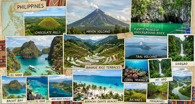
Understanding the Geography of the Philippines
READ IN TAGALOG
Pag-unawa sa Heograpiya ng Pilipinas
Madalas ilarawan ang Pilipinas bilang isang kapuluan o archipelago. Totoo ito, ngunit mas marami pang dapat malaman tungkol sa pisikal na katangian ng bansa.
Binubuo ang Pilipinas ng libu-libong isla, kabundukan, kagubatan, ilog, lawa, at malawak na yamang-dagat. Ang mga ito ay may malaking impluwensya sa kultura, ekonomiya, transportasyon, turismo, at maging sa pang-araw-araw na pamumuhay ng mga Pilipino.
Isang Bansang Binubuo ng mga Isla
Ayon sa National Mapping and Resource Information Authority (NAMRIA), may mahigit 7,600 isla ang Pilipinas.
Ang mga ito ay nahahati sa tatlong pangunahing pangkat:
- Luzon
- Visayas
- Mindanao
Hindi lahat ng isla ay tinitirhan ng tao. Ang ilan ay nagsisilbing pook-pangisdaan, protektadong lugar, o destinasyong panturismo.
Dahil kapuluan ang bansa, mahalaga ang transportasyong pandagat at panghimpapawid upang mapagdugtong ang iba’t ibang komunidad.
Nasaan ang Pilipinas?
Matatagpuan ang Pilipinas sa Timog-Silangang Asya.
Napapalibutan ito ng mga karagatan at malapit sa ilang bansa tulad ng:
- Taiwan sa hilaga
- Vietnam sa kanluran
- Malaysia sa timog-kanluran
- Indonesia sa timog
Dahil sa lokasyong ito, naging mahalagang bahagi ang Pilipinas ng kalakalan at palitan ng kultura sa rehiyon sa loob ng maraming siglo.
Mga Bundok, Kapatagan, at Bulkan
Iba-iba ang anyong lupa sa Pilipinas.
May mga malalawak na kabundukan sa Luzon, Visayas, at Mindanao. Mahalaga ang mga ito bilang pinagkukunan ng tubig at tahanan ng iba’t ibang uri ng halaman at hayop.
Kilala rin ang bansa sa mga bulkan dahil bahagi ito ng Pacific Ring of Fire.
Kabilang sa mga pinakakilalang bulkan ang:
- Mayon Volcano
- Taal Volcano
- Mount Pinatubo
- Mount Apo
Ang lupaing malapit sa mga bulkan ay kadalasang mataba at angkop para sa pagsasaka.
Mga Ilog at Lawa
Mahalaga ang mga ilog at lawa sa kabuhayan at pang-araw-araw na buhay.
Nagbibigay ang mga ito ng tubig, pagkain, at kabuhayan sa maraming komunidad.
Ilan sa mga kilalang lawa sa bansa ay:
- Laguna de Bay
- Taal Lake
- Lake Lanao
Malaki rin ang papel ng mga ito sa lokal na ekonomiya at kalikasan.
Mayamang Kalikasan at Biodiversity
Kilala ang Pilipinas bilang isa sa mga bansang may pinakamataas na biodiversity sa mundo.
Dahil sa dami ng mga isla at iba’t ibang uri ng kapaligiran, maraming halaman at hayop ang matatagpuan lamang sa bansa.
Kabilang dito ang:
- Tropikal na kagubatan
- Mangrove forests
- Coral reefs
- Kabundukan
- Wetlands
Mahalaga ang mga likas na yamang ito para sa turismo, pangingisda, pananaliksik, at konserbasyon.
Klima at Panahon
May tropikal na klima ang Pilipinas.
Karaniwan itong may:
- Tag-init o mas tuyong panahon
- Tag-ulan o mas maulang panahon
Nagkakaiba ang klima depende sa lokasyon at taas ng lugar.
Dahil matatagpuan ang bansa sa typhoon belt ng Kanlurang Pasipiko, madalas din itong daanan ng mga bagyo.
Paano Ito Nakaaapekto sa Pang-araw-araw na Buhay?
Malaki ang epekto ng heograpiya sa pamumuhay ng mga tao.
Halimbawa:
- Umaasa ang mga magsasaka sa matabang lupa at sapat na tubig.
- Nakadepende ang mga mangingisda sa yamang-dagat.
- Maraming destinasyong panturismo ang nakabatay sa likas na tanawin.
- Ang sistema ng transportasyon ay kailangang umangkop sa pagiging kapuluan ng bansa.
Maging ang pagkakaiba-iba ng kultura sa iba’t ibang rehiyon ay bahagyang naimpluwensiyahan ng mga dagat at kabundukang naghihiwalay sa mga komunidad.
Panghuling Kaisipan
Ang heograpiya ng Pilipinas ay tumutulong upang maunawaan kung bakit magkakaiba ang mga rehiyon, kabuhayan, at paraan ng pamumuhay sa bansa.
Mahalaga itong kaalaman para sa mga biyahero, estudyante, mananaliksik, negosyante, at sinumang gustong mas makilala ang Pilipinas.
Mga Dapat Tandaan
- Mahigit 7,600 isla ang bumubuo sa Pilipinas.
- Nahahati ang bansa sa Luzon, Visayas, at Mindanao.
- Matatagpuan ito sa Timog-Silangang Asya.
- Bahagi ito ng Pacific Ring of Fire.
- Mayaman ang bansa sa kabundukan, kagubatan, ilog, lawa, at coral reefs.
- Kinikilala ang Pilipinas bilang isa sa mga biodiversity hotspots sa mundo.
- Malaki ang impluwensya ng heograpiya sa kultura, ekonomiya, at pang-araw-araw na buhay.
Karagdagang Sanggunian
National Mapping and Resource Information Authority (NAMRIA)
https://www.namria.gov.ph
Philippine Statistics Authority (PSA)
https://psa.gov.ph
Department of Environment and Natural Resources (DENR)
https://www.denr.gov.ph
Philippine Institute of Volcanology and Seismology (PHIVOLCS)
https://www.phivolcs.dost.gov.ph
The Philippines is often described as an archipelago, but that simple definition only tells part of the story. Stretching across Southeast Asia, the country consists of thousands of islands, diverse landscapes, and some of the world’s richest marine ecosystems.
Its geography influences almost every aspect of life—from culture and transportation to agriculture, tourism, trade, and disaster preparedness. Understanding the country’s physical features helps explain why different parts of the Philippines can feel so distinct from one another.
A Nation of Islands
According to the National Mapping and Resource Information Authority (NAMRIA), the Philippines consists of more than 7,600 islands spread across the western Pacific Ocean.
These islands are grouped into three major island clusters:
- Luzon
- Visayas
- Mindanao
Not all islands are inhabited. Many remain unoccupied, while others serve as important fishing grounds, protected areas, or tourism destinations.
Because the country is made up of islands, sea travel and air travel play an important role in connecting communities and supporting economic activity.
Where the Philippines Is Located
The Philippines is located in Southeast Asia, between the Philippine Sea and the South China Sea.
Its nearest neighbors include:
- Taiwan to the north
- Vietnam to the west
- Malaysia to the southwest
- Indonesia to the south
This strategic location has historically made the Philippines an important crossroads for trade, migration, and cultural exchange.
Today, it continues to play a significant role in regional commerce and maritime activities.
Mountains, Plains, and Volcanoes
The country’s landscape is remarkably varied.
Mountain ranges can be found throughout Luzon, Visayas, and Mindanao. These highland areas provide watersheds, agricultural land, and habitats for unique plant and animal species.
The Philippines is also home to many volcanoes because it lies along the Pacific Ring of Fire, a region known for volcanic and seismic activity.
Some of the country’s most well-known volcanoes include:
- Mayon Volcano
- Taal Volcano
- Mount Pinatubo
- Mount Apo
Many volcanic areas have fertile soil, which supports farming and agricultural production.
Rivers and Lakes
Freshwater resources play an important role in daily life and economic development.
Major rivers support agriculture, transportation, and local communities, while lakes provide water, fisheries, and recreational opportunities.
Among the country’s notable lakes are:
- Laguna de Bay
- Taal Lake
- Lake Lanao
These bodies of water contribute to local livelihoods and regional ecosystems.
One of the World’s Most Biodiverse Countries
The Philippines is recognized as one of the world’s biodiversity hotspots.
Its geographic isolation and varied environments have allowed many species to evolve that are found nowhere else on Earth.
The country contains:
- Tropical rainforests
- Mangrove forests
- Coral reefs
- Mountain ecosystems
- Coastal wetlands
This biodiversity supports tourism, fisheries, scientific research, and environmental conservation efforts.
Climate and Weather
The Philippines has a tropical climate characterized by warm temperatures and relatively high humidity throughout the year.
The country generally experiences:
- A dry season
- A rainy season
Weather patterns can vary depending on location, elevation, and seasonal wind systems.
The Philippines is also located within the western Pacific typhoon belt, making it one of the countries frequently affected by tropical cyclones.
Understanding local geography helps communities prepare for weather-related hazards and natural disasters.
Why Geography Matters to Everyday Life
Geography affects how people live, work, and travel.
For example:
- Farmers depend on fertile plains, rainfall, and river systems.
- Fishing communities rely on coastal and marine resources.
- Tourism often develops around beaches, mountains, lakes, and natural attractions.
- Transportation networks must adapt to an island-based geography.
Even regional cultures have been shaped by the physical separation created by mountains, seas, and islands.
Final Thoughts
The geography of the Philippines helps explain many aspects of the country’s identity and development.
It influences where people settle, how goods move, what crops are grown, and how communities prepare for natural hazards.
For travelers, understanding geography provides valuable context when exploring different regions.
For students and researchers, it offers insight into the relationship between nature, society, and economic activity.
For entrepreneurs and investors, geography can affect logistics, infrastructure, tourism potential, and access to natural resources.
Useful Things to Remember
- The Philippines is an archipelago of more than 7,600 islands.
- The country is divided into three major island groups: Luzon, Visayas, and Mindanao.
- It is located in Southeast Asia between the Philippine Sea and the South China Sea.
- The Philippines lies along the Pacific Ring of Fire.
- Its geography includes mountains, volcanoes, rivers, lakes, forests, and coral reefs.
- The country is recognized as one of the world’s biodiversity hotspots.
- Geography influences culture, transportation, agriculture, tourism, and economic development.
Further Resources
National Mapping and Resource Information Authority (NAMRIA)
https://www.namria.gov.ph
Philippine Statistics Authority (PSA)
https://psa.gov.ph
Department of Environment and Natural Resources (DENR)
https://www.denr.gov.ph
Philippine Institute of Volcanology and Seismology (PHIVOLCS)
https://www.phivolcs.dost.gov.ph